The Trail System
(click image for pictures)
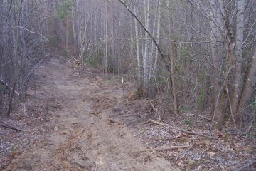
The trail systems was started on April 7, 2007. The trail system which extends throughout the property has begun. The trail system was mainly designed as a bridle path. It can be used as a foot path to observe nature at its best and worse. The trail is a series of endless loops and connections. The outer path will take you around the boundary of the property. There are several connecting trails that will take you back to the barn. Each pasture has a trail around it which connects to the boundary trail. Each orchard has a trail through or around it which connects to the barn or the boundary trail. Each grove of trees has a trail around it with a connecting trail through the grove. The northeast woods have a trail through it which connect to the back pasture, orchards and boundary. The system is design to ensure that no one gets lost on the trail.
The trail is not marked. The use of coverts to cross streams reduces the damage to the land and keeps the feet dry of travelers. Benches are placed throughout the trail to rest or just observe nature. A stream covered by a canopy of trees runs parallel to part of the northeast section of the trail system. The ground is sandy and soft to provide low impact for horses and hikers alike.
The Samuel Trail is a short trail surrounding the John T. Pasture. This is a trail is mostly mowed grass. It is open and mostly flat. It is the first trail that is seen when entering the property. The west side of the trail is parallel to the road to the barn. This portion of the trail is lined with various fruit trees.
The Robert Trail is a one third of a mile trail surrounding the William Pasture. This trail is flat and consist of mowed grass. The north side of this trail is part of the boundary trail. It connects to the Wilson trail on the northwest side, the Leonardus trail on the north east side and is parallel to the main road to the barn on the west side.
The Leonardus Loop is a one mile trail that surrounds Blagmon Grove. This trail is six feet wide at it's narrowest point extending to eight feet wide at some locations. The Mary Cross Trail and the Fannie Cross trail are connecting trails with connecting points within the Leonardus loop.
The Jackie Loop is a trail that surrounds Williams Grove. It is ten feet wide at it's narrowest point extending to twelve feet in some locations. The footing is hard packed sand with the exception of the hills. The hills have packed stone to prevent erosion. The bottom layer is number fifty-seven stone covered with crush and run which is covered with stone dust mixed with concrete. A series of small four inch culverts was covered with two feet of number fifty-seven stone which in turn was covered with one foot of sand was used in the marsh area. The Jackie Loop has two connecting trails. The first connecting trail is a cross trail that goes between the Apple Orchard and the Pear Orchard. It continues down hill to meet up again with The Jackie Loop as it runs along an intermittent creek. The second connecting trail goes through the Nectarine Orchard down a hill to meet up again with The Jackie Loop about thee hundred feet from the first connecting trail.
![]()